
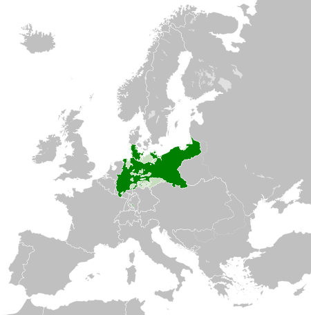
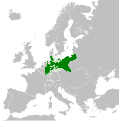
Lêer:Kingdom of Prussia 1870.svg

Size of this PNG preview of this SVG file: 450 × 456 piksels. Ander resolusies: 237 × 240 piksels | 474 × 480 piksels | 758 × 768 piksels | 1 011 × 1 024 piksels | 2 021 × 2 048 piksels.
Oorspronklike lêer (SVG-lêer, normaalweg 450 × 456 piksels, lêergrootte: 705 KG)
Opsomming
This W3C-unspecified vector image was created with Inkscape .


.svg)
.svg)
.svg)
.svg)
.svg)


.svg)
.svg)
.svg)


.png)
.png)


.svg)


.svg)

.svg)


.svg)
.svg)
.svg)
.svg)


.svg)
.png)


.svg)


.svg)
.svg)


.svg)


.svg)


.svg)
.svg)
.svg)
.svg)
.svg)
.svg)
.svg)
_cropped.svg)
.svg)
.svg)
.svg)
.svg)
.svg)
.svg)
.svg)
.svg)
.svg)
.svg)
.svg)
.svg)
.svg)
.svg)
.svg)
.svg)
.svg)
.svg)
.svg)
.svg)
.svg)
.svg)
.svg)
.svg)
.svg)
.svg)
.svg)
.svg)
.svg)
.svg)
.svg)
.svg)
.svg)
.svg)
.svg)
.svg)
.svg)
.svg)
.svg)
.svg)
.svg)
.svg)
.svg)
.svg)
.svg)
Lisensiëring
This file is licensed under the Creative Commons Attribution-Share Alike 4.0 International license.
- U is vry:
- om te deel – die werk kopieer, versprei en deurgee
- om te hermeng – om die werk aan te pas
- Onder die volgende voorwaardes:
- naamsvermelding – U moet die nodige krediet gee, 'n skakel na die lisensie verskaf en aandui of daar veranderinge aangebring is. U mag dit op enige redelike manier doen, maar nie op enige manier wat daarop dui dat die lisensiegewer u of u gebruik onderskryf nie.
- insgelyks – As u die materiaal hermix, transformeer of voortbou, moet u u bydraes versprei onder die dieselfde of versoenbare lisensie as die oorspronklike.
Lêergeskiedenis
Klik op die datum/tyd om te sien hoe die lêer destyds gelyk het.
| Datum/Tyd | Duimnael | Dimensies | Gebruiker | Opmerking | |
|---|---|---|---|---|---|
| huidig | 02:54, 1 Junie 2016 | | 450 × 456 (705 KG) | Alphathon | Various corrections to the states of the North German Confederation |
| 05:22, 31 Mei 2016 |  | 450 × 456 (662 KG) | Alphathon | Minor corrections (Tarasp and post-1818 German Confederation border change) | |
| 02:40, 31 Mei 2016 |  | 450 × 456 (662 KG) | Alphathon | == {{int:filedesc}} == {{Inkscape}} {{Information |Description={{en|A map of the en:Kingdom of Prussia within the North German Confederation and within Europe circa 1870 CE.}} |Source= {{Derived from|Blank_map_of_Europe.svg|display=50}} |Da... |
Lêergebruik
Die volgende bladsy gebruik dié lêer:
Globale lêergebruik
Die volgende ander wiki's gebruik hierdie lêer:
- Gebruik in ar.wikipedia.org
- Gebruik in bn.wikipedia.org
- Gebruik in ckb.wikipedia.org
- Gebruik in en.wikipedia.org
- Gebruik in eo.wiktionary.org
- Gebruik in es.wikipedia.org
- Gebruik in es.wiktionary.org
- Gebruik in eu.wikipedia.org
- Gebruik in fa.wikipedia.org
- Gebruik in fi.wikipedia.org
- Gebruik in he.wikipedia.org
- Gebruik in hu.wikipedia.org
- Gebruik in is.wikipedia.org
- Gebruik in it.wikipedia.org
- Gebruik in li.wiktionary.org
- Gebruik in lld.wikipedia.org
- Gebruik in lt.wikipedia.org
- Gebruik in mn.wikipedia.org
- Gebruik in pl.wikipedia.org
- Gebruik in rue.wikipedia.org
- Gebruik in ru.wikipedia.org
- Gebruik in ru.wiktionary.org
- Gebruik in sk.wikipedia.org
- Gebruik in szl.wikipedia.org
- Gebruik in tr.wikipedia.org
- Gebruik in uk.wikipedia.org
- Gebruik in uz.wikipedia.org
- Gebruik in xmf.wikipedia.org
- Gebruik in zh.wikipedia.org